


4R1 - I H Bass Jr Meml
Located in Lumberton, United States
ICAO - 4R1, IATA -
Data provided by AirmateGeneral information
Coordinates: N31°0'55" W89°28'57"
Elevation is 310 feet MSL.
Magnetic variation is 02° East View others Airports in Mississippi
Operational data
Special qualification required
Current time UTC:
Current local time:
Weather at : KHBG - Hattiesburg Bobby L Chain Muni ( 35 km )
TAF: KHBG 010530Z 0106/0206 VRB03KT 6SM -SHRA BR BKN090 FM010900 VRB04KT P6SM VCTS BKN027CB FM011200 VRB04KT 6SM TSRA BR SCT008CB FM011400 20005KT 6SM -SHRA BR BKN013 TEMPO 0114/0115 4SM TSRA BR OVC009CB FM011900 22006KT P6SM VCTS BKN060CB
Communications frequencies: [VIEW]
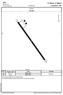
Runways:
| RWY identifier | QFU | Length (ft) | Width (ft) | Surface | LDA (ft) |
| 14 | 144° | 3000 | 75 | ASPH | |
| 32 | 324° | 3000 | 75 | ASPH |
Airport contact information
Address: Lumberton United States