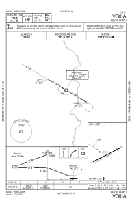
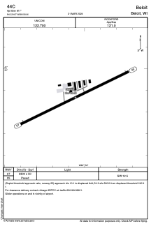


44C - Beloit
Located in Beloit, United States
ICAO - 44C, IATA -
Data provided by AirmateGeneral information
Coordinates: N42°29'52" W88°58'3"
Elevation is 817 feet MSL.
Magnetic variation is -03° East View others Airports in Wisconsin
Operational data
Special qualification required
Current time UTC:
Current local time:
Weather at : KJVL - Southern Wisconsin Rgnl ( 15 km )
METAR: KJVL 080915Z AUTO 00000KT 10SM BKN120 13/13 A2984 RMK AO2
TAF: KJVL 080836Z 0809/0906 VRB03KT P6SM SCT100 FM081600 21006KT 6SM -SHRA OVC060 FM081800 35006KT 4SM -SHRA OVC018 FM082000 02008KT P6SM OVC018 FM082200 36008KT P6SM BKN035 FM090300 29005KT P6SM FEW250
Communications frequencies: [VIEW]
Runways:
| RWY identifier | QFU | Length (ft) | Width (ft) | Surface | LDA (ft) |
| 07 | 64° | 3300 | 50 | ASPH | |
| 25 | 244° | 3300 | 50 | ASPH |
Airport contact information
Address: Beloit United States