


44A - Rolle Airfield
Located in San Luis, United States
ICAO - 44A, IATA -
Data provided by AirmateGeneral information
Coordinates: N32°30'59" W114°41'54"
Elevation is 163 feet MSL.
Magnetic variation is 13° East View others Airports in Arizona
Operational data
Special qualification required
Current time UTC:
Current local time:
Communications frequencies: [VIEW]
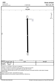
Runways:
| RWY identifier | QFU | Length (ft) | Width (ft) | Surface | LDA (ft) |
| 17 | 0° | 2800 | 60 | ASPH | |
| 35 | 0° | 2800 | 60 | ASPH |
Airport contact information
Address: San Luis United States