


30KS - Flugplatz
Located in Hutchinson, United States
ICAO - 30KS, IATA -
Data provided by AirmateGeneral information
Coordinates: N38°1'29" W97°44'2"
Elevation is 1471 feet MSL.
View others Airports in Kansas
Operational data
Special qualification required
Current time UTC:
Current local time:
Weather at : KHUT - Hutchinson Rgnl ( 12 km )
METAR: KHUT 290752Z AUTO 34003KT 10SM CLR 13/12 A3013 RMK AO2 SLP187 T01280122
TAF: KHUT 290533Z 2906/3006 10004KT P6SM BKN150 FM291400 13012KT P6SM BKN160 FM291800 15014G21KT P6SM SCT080 FM300100 14013KT P6SM FEW150
Communications frequencies: [VIEW]
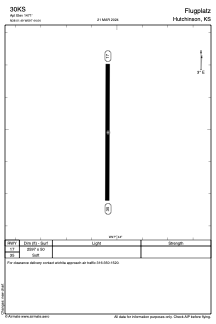
Runways:
| RWY identifier | QFU | Length (ft) | Width (ft) | Surface | LDA (ft) |
| 17 | 0° | 2597 | 50 | GRASS | |
| 35 | 0° | 2597 | 50 | GRASS |
Airport contact information
Address: Hutchinson United States