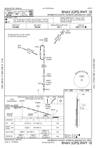
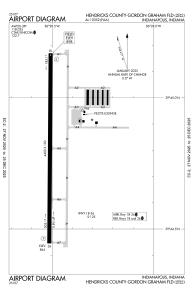


2R2 - Hendricks County-Gordon Graham Fld
Located in Indianapolis, United States
ICAO - 2R2, IATA -
Data provided by AirmateGeneral information
Coordinates: N39°44'48" W86°28'31"
Elevation is 898 feet MSL.
Magnetic variation is -03° East View others Airports in Indiana
Operational data
Special qualification required
Current time UTC:
Current local time:
Communications frequencies: [VIEW]
Runways:
| RWY identifier | QFU | Length (ft) | Width (ft) | Surface | LDA (ft) |
| 18 | 180° | 4400 | 100 | ASPH | |
| 36 | 0° | 4400 | 100 | ASPH |
Airport contact information
Address: Indianapolis United States
