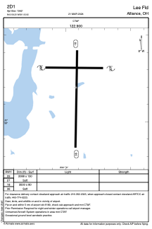


2D1 - Lee Fld
Located in Alliance, United States
ICAO - 2D1, IATA -
Data provided by AirmateGeneral information
Coordinates: N40°58'12" W81°5'55"
Elevation is 1062 feet MSL.
Magnetic variation is -07° East View others Airports in Ohio
Operational data
Special qualification required
Current time UTC:
Current local time:
Communications frequencies: [VIEW]
Runways:
| RWY identifier | QFU | Length (ft) | Width (ft) | Surface | LDA (ft) |
| 09 | 0° | 2088 | 130 | GRASS | |
| 27 | 0° | 2088 | 130 | GRASS | |
| 18 | 0° | 3500 | 80 | GRASS | |
| 36 | 0° | 3500 | 80 | GRASS |
Airport contact information
Address: Alliance United States