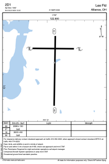


2D1 - Lee Fld
Located in Alliance, United States
ICAO - 2D1, IATA -
Data provided by AirmateGeneral information
Coordinates: N40°58'12" W81°5'55"
Elevation is 1062 feet MSL.
Magnetic variation is -07° East View others Airports in Ohio
Operational data
Special qualification required
Current time UTC:
Current local time:
Weather at : KCAK - Akron-Canton Rgnl ( 30 km )
METAR: KCAK 011751Z 15008KT 10SM SCT250 23/09 A3016 RMK AO2 SLP209 T02330089 10239 20133 58017 $
TAF: KCAK 011741Z 0118/0218 16008KT P6SM BKN250 FM021100 23007KT P6SM -SHRA OVC035 FM021300 18008KT 5SM -SHRA BR OVC015 TEMPO 0213/0216 4SM -RA BR OVC009
Communications frequencies: [VIEW]
Runways:
| RWY identifier | QFU | Length (ft) | Width (ft) | Surface | LDA (ft) |
| 09 | 0° | 2088 | 130 | GRASS | |
| 27 | 0° | 2088 | 130 | GRASS | |
| 18 | 0° | 3500 | 80 | GRASS | |
| 36 | 0° | 3500 | 80 | GRASS |
Airport contact information
Address: Alliance United States