


25TS - Miller Airfield
Located in Dalhart, United States
ICAO - 25TS, IATA -
Data provided by AirmateGeneral information
Coordinates: N36°5'30" W102°24'57"
Elevation is 3961 feet MSL.
Magnetic variation is 10° East View others Airports in Texas
Operational data
Special qualification required
Current time UTC:
Current local time:
Communications frequencies: [VIEW]
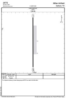
Runways:
| RWY identifier | QFU | Length (ft) | Width (ft) | Surface | LDA (ft) |
| 17 | 180° | 6173 | 74 | CONC | |
| 35 | 360° | 6173 | 74 | CONC |
Airport contact information
Address: Dalhart United States