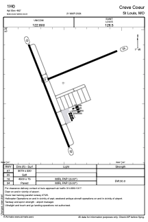


1H0 - Creve Coeur
Located in St Louis, United States
ICAO - 1H0, IATA -
Data provided by AirmateGeneral information
Coordinates: N38°43'38" W90°30'30"
Elevation is 462 feet MSL.
Magnetic variation is 00° East View others Airports in Missouri
Operational data
Special qualification required
Current time UTC:
Current local time:
Communications frequencies: [VIEW]
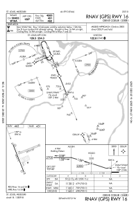
Runways:
| RWY identifier | QFU | Length (ft) | Width (ft) | Surface | LDA (ft) |
| 07 | 68° | 3079 | 220 | GRASS | |
| 25 | 248° | 3079 | 220 | GRASS | |
| 16 | 158° | 4500 | 75 | CONC | |
| 34 | 338° | 4500 | 75 | CONC |
Airport contact information
Address: St Louis United States
