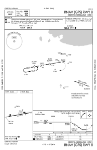
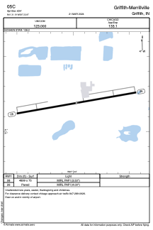


05C - Griffith-Merrillville
Located in Griffith, United States
ICAO - 05C, IATA -
Data provided by AirmateGeneral information
Coordinates: N41°31'11" W87°23'58"
Elevation is 634 feet MSL.
Magnetic variation is -03° East View others Airports in Indiana
Operational data
Special qualification required
Current time UTC:
Current local time:
Communications frequencies: [VIEW]
Runways:
| RWY identifier | QFU | Length (ft) | Width (ft) | Surface | LDA (ft) |
| 08 | 80° | 4899 | 75 | ASPH | |
| 26 | 260° | 4899 | 75 | ASPH |
Airport contact information
Address: Griffith United States
