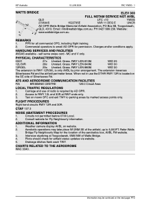


YWSG - Watts Bridge
Located in Toogoolawah, Australia
ICAO - YWSG, IATA -
Data provided by AirmateGeneral information
Coordinates: S27°5'40" E152°27'35"
Elevation is 300 feet MSL.
Magnetic variation is 11° East View others Airports in Queensland
Operational data
Special qualification required
Current time UTC:
Current local time:
Weather at : YAMB - Amberley ( 66 km )
METAR: YAMB 270000Z AUTO 06003KT 9999 // FEW003 17/16 Q1023 RF00.0/000.0
TAF: TAF YAMB 262341Z 2700/2800 32007KT 9999 SCT020 FM270600 02008KT 9999 -SHRA SCT050 FM271100 34006KT 9999 -SHRA SCT020 BKN050 FM271400 27008KT 9999 -SHRA SCT020 BKN050 INTER 2712/2800 3000 SHRA BKN015
Communications frequencies: [VIEW]
Runways:
| RWY identifier | QFU | Length (ft) | Width (ft) | Surface | LDA (ft) |
| 03 | 0° | 2657 | 82 | G | |
| 21 | 0° | 2657 | 82 | G | |
| 12L | 0° | 2756 | 98 | UNK | |
| 30R | 0° | 2756 | 98 | UNK | |
| 12R | 0° | 2887 | 98 | UNK | |
| 30L | 0° | 2887 | 98 | UNK | |
| 30 | 309° | 2969 | 94 | GRAS | |
| 12 | 129° | 2969 | 94 | GRAS | |
| 18 | 192° | 3 | 85 | GRAS | |
| 00 | 12° | 3 | 85 | GRAS |
Airport contact information
Address: Toogoolawah Australia
