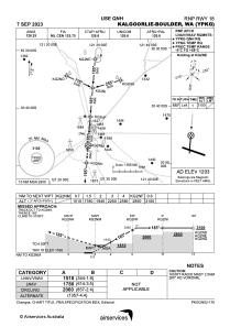
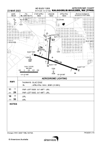


YPKG - Kalgoorlie-Boulder
Located in Kalgoorlie/Boulder, Australia
ICAO - YPKG, IATA - KGI
Data provided by AirmateGeneral information
Coordinates: S30°47'22" E121°27'42"
Elevation is 1203 feet MSL.
View others Airports in Western Australia
Operational data
Special qualification required
Current time UTC:
Current local time:
Weather
METAR: YPKG 260930Z AUTO 14006KT 9999 // SCT100 14/09 Q1020 RF00.0/000.4
TAF: TAF YPKG 260504Z 2606/2706 06008KT CAVOK FM270000 36008KT CAVOK
Communications frequencies: [VIEW]
Runways:
| RWY identifier | QFU | Length (ft) | Width (ft) | Surface | LDA (ft) |
| 11 | 110° | 6562 | 148 | ASP | |
| 29 | 290° | 6562 | 148 | ASP | |
| 18 | 185° | 3937 | 59 | ASP | |
| 36 | 5° | 3937 | 59 | ASP |
Airport contact information
Address: Kalgoorlie/Boulder Australia
