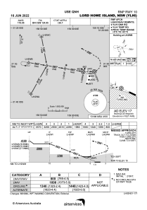
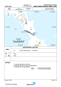


YLHI - Lord Howe Island
Located in Lord Howe Island, Australia
ICAO - YLHI, IATA - LDH
Data provided by AirmateGeneral information
Coordinates: S31°32'18" E159°4'38"
Elevation is 17 feet MSL.
View others Airports in New South Wales
Operational data
Special qualification required
Current time UTC:
Current local time:
Weather
METAR: YLHI 022000Z AUTO 13002KT 9999 // SCT021 SCT034 SCT048 16/14 Q1026
TAF: TAF AMD YLHI 021938Z 0219/0318 13010KT 9999 -SHRA SCT020 BKN030 INTER 0219/0306 4000 SHRA SCT015 BKN020 INTER 0312/0318 4000 SHRA SCT015 BKN020
Communications frequencies: [VIEW]
Runways:
| RWY identifier | QFU | Length (ft) | Width (ft) | Surface | LDA (ft) |
| 10 | 114° | 2913 | 98 | B | |
| 28 | 294° | 2913 | 98 | B |
Airport contact information
Address: Lord Howe Island Australia