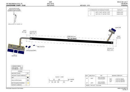


WIHC - Cibubur / Wiladatika
Located in Cibubur, Indonesia
ICAO - , IATA -
Data provided by AirmateGeneral information
Coordinates: S6°21'25" E106°53'49"
Elevation is 210 feet MSL.
View others Airports in Jakarta Raya
Operational data
Special qualification required
Current time UTC:
Current local time:
Weather at : WIHH - Jakarta/Halim Perdanakusuma ( 10 km )
METAR: WIHH 262330Z 00000KT 3000 HZ FEW022 24/22 Q1012 NOSIG METAR
TAF: TAF WIHH 262300Z 2700/2800 12008KT 5000 HZ FEW022 BECMG 2703/2705 04010KT 6000 SCT020
Communications frequencies: [VIEW]
Runways:
| RWY identifier | QFU | Length (ft) | Width (ft) | Surface | LDA (ft) |
| 09 | 93° | 2493 | 66 | UNK | |
| 27 | 273° | 2493 | 66 | UNK |
Airport contact information
Address: Cibubur Indonesia