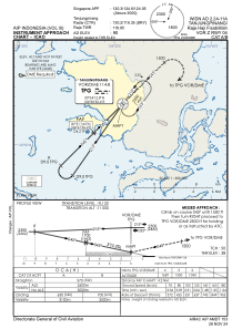
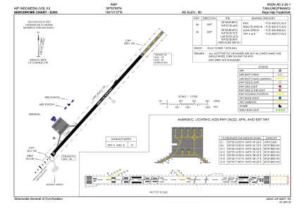


WIDN - Tanjungpinang/Raja Haji Fisabilillah
Located in Tanjungpinang, Indonesia
ICAO - WIDN, IATA - TNJ
Data provided by AirmateGeneral information
Coordinates: N0°55'8" E104°31'37"
Elevation is 94 feet MSL.
View others Airports in Riau
Operational data
Special qualification required
Current time UTC:
Current local time:
Weather at : WIDD - Batam / Hang Nadim ( 51 km )
METAR: WIDD 270430Z 08006KT 9999 FEW014 33/24 Q1009 NOSIG
TAF: TAF WIDD 262300Z 2700/2724 10007KT 9999 SCT014
Communications frequencies: [VIEW]
Runways:
| RWY identifier | QFU | Length (ft) | Width (ft) | Surface | LDA (ft) |
| 04 | 42° | 8202 | 148 | ASP | |
| 22 | 222° | 8202 | 148 | ASP |
Airport contact information
Address: Tanjungpinang Indonesia