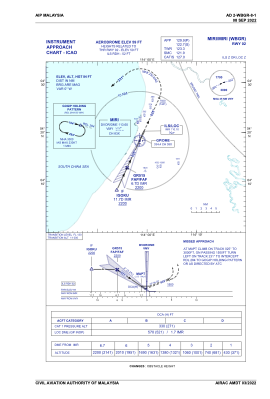


WBGR - Miri
Located in Miri, Malaysia
ICAO - WBGR, IATA - MYY
Data provided by AirmateGeneral information
Coordinates: N4°19'21" E113°59'14"
Elevation is 59 feet MSL.
View others Airports in Sarawak
Operational data
Special qualification required
Current time UTC:
Current local time:
Weather
METAR: WBGR 080200Z 30004KT 240V020 9999 SCT014 29/26 Q1010
TAF: TAF WBGR 072300Z 0800/0900 10005KT 9999 FEW016
Communications frequencies: [VIEW]
Runways:
| RWY identifier | QFU | Length (ft) | Width (ft) | Surface | LDA (ft) |
| 02 | 25° | 9006 | 197 | ASP | |
| 20 | 205° | 9006 | 197 | ASP |
Airport contact information
Address: Miri Malaysia