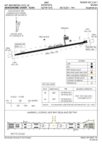


WAWR - Muna / Sugimanuru
Located in Sugimanuru, Indonesia
ICAO - , IATA - RAQ
Data provided by AirmateGeneral information
Coordinates: S4°45'43" E122°34'12"
Elevation is 141 feet MSL.
View others Airports in Sulawesi Tenggara
Operational data
Special qualification required
Current time UTC:
Current local time:
Weather at : - ( 0 km )
METAR: PAMY 260827Z AUTO 10006KT 3SM BR OVC003 M01/M01 A2973 RMK AO2 UPE14 P0000 FZRANO
Communications frequencies: [VIEW]
Runways:
| RWY identifier | QFU | Length (ft) | Width (ft) | Surface | LDA (ft) |
| 08 | 81° | 5249 | 98 | UNK | |
| 26 | 261° | 5249 | 98 | UNK |
Airport contact information
Address: Sugimanuru Indonesia