


WATP - Alor / Pantar
Located in , Indonesia
ICAO - , IATA -
Data provided by AirmateGeneral information
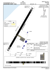
Coordinates: S8°14'45" E124°13'7"
Elevation is 18 feet MSL.
View others Airports in Nusa Tenggara Timur
Operational data
Special qualification required
Current time UTC:
Current local time:
Weather at : - ( 0 km )
METAR: KAFP 070811Z AUTO 17003KT 10SM -RA OVC110 19/18 A2989 RMK AO2 P0004 T01860180
Communications frequencies: [VIEW]
Runways:
| RWY identifier | QFU | Length (ft) | Width (ft) | Surface | LDA (ft) |
| 03 | 30° | 2953 | 98 | UNK | |
| 21 | 210° | 2953 | 98 | UNK |
Airport contact information
Address: Indonesia