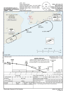
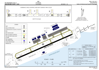


WALL - Balikpapan / Sultan Aji Muhammad Sulaiman Sepinggan
Located in Balikpapan, Indonesia
ICAO - WALL, IATA - BPN
Data provided by AirmateGeneral information
Coordinates: S1°16'3" E116°53'38"
Elevation is 12 feet MSL.
View others Airports in East Kalimantan
Operational data
Special qualification required
Current time UTC:
Current local time:
Weather
METAR: WALL 260900Z 07008KT 050V120 9999 FEW020CB FEW022 30/27 Q1005 RMK CB TO NW AND W
TAF: TAF WALL 260500Z 2606/2712 08007KT 9999 SCT020
Communications frequencies: [VIEW]
Runways:
| RWY identifier | QFU | Length (ft) | Width (ft) | Surface | LDA (ft) |
| 07 | 67° | 8202 | 148 | ASP | |
| 25 | 247° | 8202 | 148 | ASP |
Airport contact information
Address: Balikpapan Indonesia