


WAGI - Pangkalan Bun / Iskandar
Located in Pangkalan Bun, Indonesia
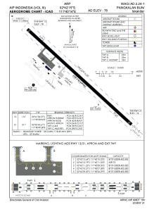
ICAO - , IATA - PKN
Data provided by AirmateGeneral information
Coordinates: S2°42'15" E111°40'14"
Elevation is 78 feet MSL.
View others Airports in Kalimantan Timur
Operational data
Special qualification required
Current time UTC:
Current local time:
Weather at : - ( 0 km )
METAR: KIFP 261552Z 20011KT 10SM CLR 20/03 A2974
Communications frequencies: [VIEW]
Runways:
| RWY identifier | QFU | Length (ft) | Width (ft) | Surface | LDA (ft) |
| 13 | 132° | 6955 | 148 | UNK | |
| 31 | 312° | 6955 | 148 | UNK |
Airport contact information
Address: Pangkalan Bun Indonesia