


WADY - Banyuwangi / Banyuwangi
Located in Banyuwangi, Indonesia
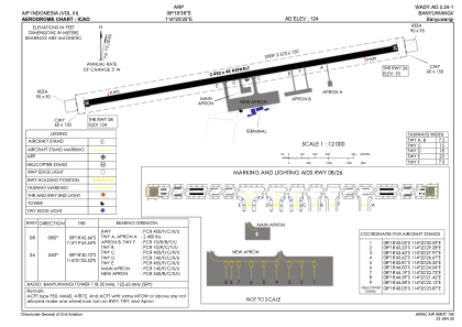
ICAO - , IATA - BWX
Data provided by AirmateGeneral information
Coordinates: S8°18'38" E114°20'25"
Elevation is 120 feet MSL.
View others Airports in Jawa Timur
Operational data
Special qualification required
Current time UTC:
Current local time:
Weather at : - ( 0 km )
METAR: PFWS 262333Z AUTO 24014G19KT 10SM BKN013 BKN028 OVC034 12/09 A2995 RMK AO2
Communications frequencies: [VIEW]
Runways:
| RWY identifier | QFU | Length (ft) | Width (ft) | Surface | LDA (ft) |
| 08 | 81° | 8038 | 148 | UNK | |
| 26 | 261° | 8038 | 148 | UNK |
Airport contact information
Address: Banyuwangi Indonesia