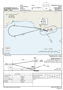
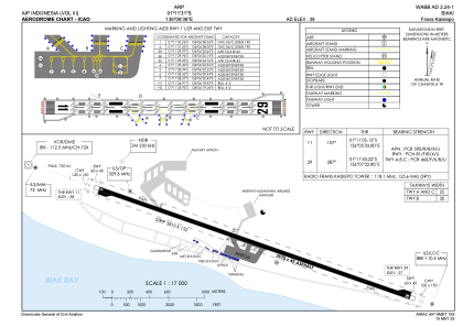


WABB - Biak/Frans Kaisiepo
Located in Biak, Indonesia
ICAO - WABB, IATA - BIK
Data provided by AirmateGeneral information
Coordinates: S1°11'31" E136°6'36"
Elevation is 38 feet MSL.
View others Airports in Papua
Operational data
Special qualification required
Current time UTC:
Current local time:
Weather
METAR: WABB 260800Z 02006KT 020V260 9999 SCT015 30/26 Q1007 NOSIG
TAF: TAF WABB 260500Z 2606/2712 04005KT 9999 SCT015 TEMPO 2606/2608 5000 RA BKN015 BECMG 2610/2612 00000KT
Communications frequencies: [VIEW]
Runways:
| RWY identifier | QFU | Length (ft) | Width (ft) | Surface | LDA (ft) |
| 11 | 109° | 11713 | 148 | ASP | |
| 29 | 289° | 11713 | 148 | ASP |
Airport contact information
Address: Biak Indonesia