


W20 - Moses Lake Muni
Located in Moses Lake, United States
ICAO - W20, IATA -
Data provided by AirmateGeneral information
Coordinates: N47°8'31" W119°14'16"
Elevation is 1205 feet MSL.
Magnetic variation is 19° East View others Airports in Washington
Operational data
Special qualification required
Current time UTC:
Current local time:
Weather at : KMWH - Grant County Intl ( 10 km )
METAR: KMWH 050652Z 34012KT 10SM OVC085 13/06 A2946 RMK AO2 SLP973 T01330056 $
TAF: KMWH 050520Z 0506/0606 01007KT P6SM SCT070 OVC100 PROB30 0507/0510 4SM -RA BR BKN070 FM051000 19007KT P6SM -RA SCT060 OVC090 FM052100 23009KT 5SM -RA BR SCT020 BKN035 FM060000 24012KT 5SM BR BKN045 PROB30 0600/0602 2SM -RA BR OVC015 FM060200 24012KT 6SM BR BKN060 PROB30 0602/0605 4SM -RA BR OVC025 FM060500 24012KT P6SM SCT060 WS020/28035KT PROB30 0605/0606 4SM -RA BR BKN060
Communications frequencies: [VIEW]
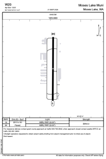
Runways:
| RWY identifier | QFU | Length (ft) | Width (ft) | Surface | LDA (ft) |
| 16 | 0° | 2513 | 50 | ASPH | |
| 34 | 0° | 2513 | 50 | ASPH |
Airport contact information
Address: Moses Lake United States
