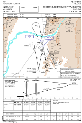
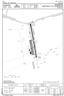


UTDT - Bokhtar
Located in Bokhtar, Tajikistan
ICAO - UTDT, IATA - KQT
Data provided by AirmateGeneral information
Coordinates: N37°52'2" E68°51'52"
Elevation is 1479 feet MSL.
View others Airports in Khatlon Province
Operational data
Special qualification required
Current time UTC:
Current local time:
Weather
METAR: UTDT 291230Z 16002MPS 9999 SCT043 BKN060CB OVC090 16/03 Q1021 R35/19//60 RMK QFE726/0968
TAF: TAF UTDT 291201Z 2913/3001 VRB02MPS 8000 SCT040CB BKN080 TEMPO 2913/3001 3100 -SHRA BR
Communications frequencies: [VIEW]
Runways:
| RWY identifier | QFU | Length (ft) | Width (ft) | Surface | LDA (ft) |
| 17 | 170° | 8038 | 138 | UNK | |
| 35 | 350° | 8038 | 138 | UNK |
Airport contact information
Address: Bokhtar Tajikistan