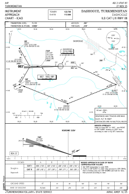
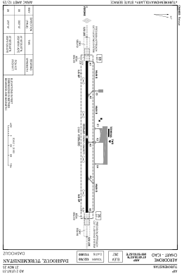


UTAT - Dashoguz
Located in Dashoguz, Turkmenistan
ICAO - UTAT, IATA - TAZ
Data provided by AirmateGeneral information
Coordinates: N41°45'36" E59°50'4"
Elevation is 282 feet MSL.
View others Airports in Dasoguz
Operational data
Special qualification required
Current time UTC:
Current local time:
Weather
METAR: UTAT 071700Z 18008KT 9999 FEW066CB OVC100 24/11 Q1010 R08/CLRD70 NOSIG
TAF: TAF UTAT 071636Z 0718/0818 13016G26KT 6000 SCT030CB OVC050 TEMPO 0718/0724 VRB22G32KT 0500 TSRA DS VV002 TEMPO 0800/0806 25020G30KT 2000 TSRA SCT020CB OVC020
Communications frequencies: [VIEW]
Runways:
| RWY identifier | QFU | Length (ft) | Width (ft) | Surface | LDA (ft) |
| 08 | 90° | 12467 | 197 | UNK | |
| 26 | 270° | 12467 | 197 | UNK |
Airport contact information
Address: Dashoguz Turkmenistan