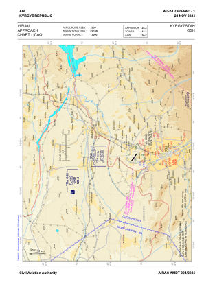
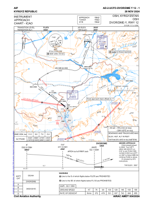
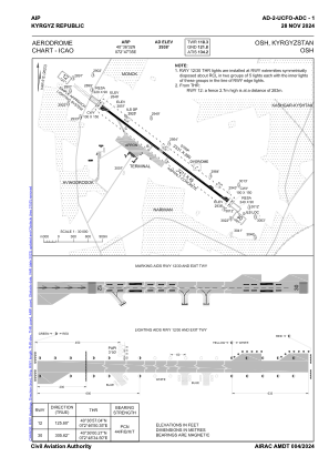


UCFO - Osh
Located in Osh, Kyrgyzstan
ICAO - , IATA - OSS
Data provided by AirmateGeneral information
Coordinates: N40°36'32" E72°47'36"
Elevation is 2938 feet MSL.
Magnetic variation is +4° East View others Airports in Osh
Operational data
Special qualification required
Current time UTC:
Current local time:
Weather
METAR: UCFO 260900Z 04002MPS 9999 SCT050CB 19/11 Q1014 NOSIG
TAF: TAF UCFO 260447Z 2606/2706 32003G08MPS 9999 SCT050CB BKN100 TEMPO 2606/2612 24008G14MPS 1500 SHRA BR SCT010 BKN030CB PROB40 TEMPO 2606/2612 -TSRA BKN020CB BECMG 2612/2614 18003G08MPS TEMPO 2612/2618 27003G08MPS 2000 TSRA BR SCT008 BKN020CB
Communications frequencies: [VIEW]
Runways:
| RWY identifier | QFU | Length (ft) | Width (ft) | Surface | LDA (ft) |
| 12 | 126° | 10538 | 148 | CONC+ASPH | 9882 |
| 30 | 306° | 10538 | 148 | CONC+ASPH | 10538 |
Airport contact information
Address: Osh Kyrgyzstan