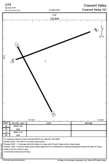


U74 - Crescent Valley
Located in Crescent Valley, United States
ICAO - U74, IATA -
Data provided by AirmateGeneral information
Coordinates: N40°24'57" W116°33'49"
Elevation is 4791 feet MSL.
Magnetic variation is 16° East View others Airports in Nevada
Operational data
Special qualification required
Current time UTC:
Current local time:
Weather at : KBAM - Battle Mountain ( 33 km )
METAR: KBAM 270015Z AUTO 02011KT 10SM SCT034 BKN043 BKN055 10/04 A2982 RMK AO1
TAF: KBAM 262320Z 2700/2724 32011KT P6SM VCSH SCT012 BKN025 FM270300 30007KT P6SM VCSH SCT013 BKN040 FM270500 30005KT P6SM SCT050 FM271000 VRB03KT P6SM VCFG FEW050 FM271800 26010G19KT P6SM BKN050
Communications frequencies: [VIEW]
Runways:
| RWY identifier | QFU | Length (ft) | Width (ft) | Surface | LDA (ft) |
| 05 | 70° | 5424 | 60 | EARTH | |
| 23 | 250° | 5424 | 60 | EARTH | |
| 14 | 152° | 4650 | 75 | EARTH | |
| 32 | 332° | 4650 | 75 | EARTH |
Airport contact information
Address: Crescent Valley United States