


U64 - Monticello
Located in Monticello, United States
ICAO - U64, IATA -
Data provided by AirmateGeneral information
Coordinates: N37°55'57" W109°20'28"
Elevation is 6970 feet MSL.
Magnetic variation is 09° East View others Airports in Utah
Operational data
Special qualification required
Current time UTC:
Current local time:
Weather at : KBDG - Blanding Muni ( 41 km )
METAR: KBDG 270135Z AUTO 25011KT 10SM SCT060 BKN075 OVC090 09/01 A2969 RMK AO2 WSHFT 0051 RAB0101E0114 P0000 T00950012
Communications frequencies: [VIEW]
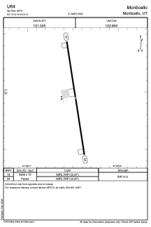
Runways:
| RWY identifier | QFU | Length (ft) | Width (ft) | Surface | LDA (ft) |
| 16 | 171° | 5998 | 75 | ASPH | |
| 34 | 351° | 5998 | 75 | ASPH |
Airport contact information
Address: Monticello United States