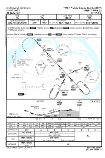


SBTF - Prefeito Orlando Marinho
Located in Tefé, Brazil
ICAO - SBTF, IATA - TFF
Data provided by AirmateGeneral information
Coordinates: S3°22'49" W64°43'31"
Elevation is 186 feet MSL.
Magnetic variation is -13.5° East View others Airports in Amazonas
Operational data
Special qualification required
Current time UTC:
Current local time:
Weather
METAR: SBTF 291300Z 18008KT 9999 SCT008 BKN080 24/21 Q1017
TAF: TAF SBTF 290900Z 2912/2924 19007KT 7000 BKN015 TX25/2917Z TN23/2924Z TEMPO 2912/2915 4000 DZ BR BKN006 BECMG 2915/2918 BKN017 FEW025TCU PROB40 TEMPO 2918/2922 5000 TSRA BKN015 FEW027CB RMK PHN
Communications frequencies: [VIEW]
Runways:
| RWY identifier | QFU | Length (ft) | Width (ft) | Surface | LDA (ft) |
| 15 | 0° | 7612 | 919 | ASPH | |
| 33 | 0° | 7612 | 919 | ASPH |
Airport contact information
Address: Tefé Brazil