

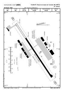


SBTA - Base De Aviação De Taubaté
Located in Taubaté, Brazil
ICAO - SBTA, IATA - QHP
Data provided by AirmateGeneral information
Coordinates: S23°2'20" W45°30'57"
Elevation is 1902 feet MSL.
View others Airports in São Paulo
Operational data
Special qualification required
Current time UTC:
Current local time:
Weather
METAR: SBTA 262200Z 14004KT 110V170 9999 SCT030 24/20 Q1016
Communications frequencies: [VIEW]
Runways:
| RWY identifier | QFU | Length (ft) | Width (ft) | Surface | LDA (ft) |
| 26 | 0° | 4921 | 98 | ASPH | |
| 08 | 0° | 4921 | 98 | ASPH |
Airport contact information
Address: Taubaté Brazil
Other aviation service providers
Aviation club (not for profit)

Aeroclube Regional Taubate
Aeroclube Regional Taubate
secretaria@aeroclubedetaubate.com.br+55123621-2277