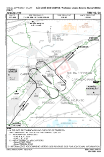
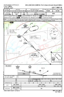
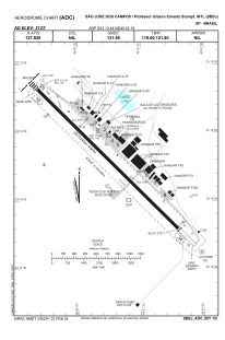


SBSJ - São José Dos Campos / Professor Urbano Ernesto Stumpf
Located in São José Dos Campos / Professor Urbano Ernesto Stumpf, Brazil
ICAO - SBSJ, IATA - SJK
Data provided by AirmateGeneral information
Coordinates: S23°13'44" W45°52'16"
Elevation is 2122 feet MSL.
Magnetic variation is -22.0° East View others Airports in São Paulo
Operational data
Special qualification required
Current time UTC:
Current local time:
Weather
METAR: SBSJ 272100Z 02003KT 340V060 CAVOK 28/19 Q1014
TAF: TAF SBSJ 271545Z 2718/2806 34006KT 9999 FEW025 TX30/2719Z TN19/2806Z BECMG 2721/2723 12006KT BECMG 2801/2803 09004KT RMK PGM
Communications frequencies: [VIEW]
Runways:
| RWY identifier | QFU | Length (ft) | Width (ft) | Surface | LDA (ft) |
| 16 | 135° | 3121 | 300 | ASPH | |
| 34 | 315° | 3121 | 300 | ASPH |
Airport contact information
Address: São José Dos Campos / Professor Urbano Ernesto Stumpf Brazil
Other aviation service providers
Aviation club (not for profit)

Aeroclube De São José Dos Campos
Aeroclube De São José Dos Campos
matriculas@aerosjc.com.br+551298132-2641