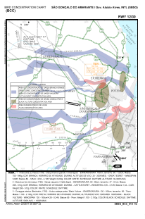
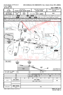
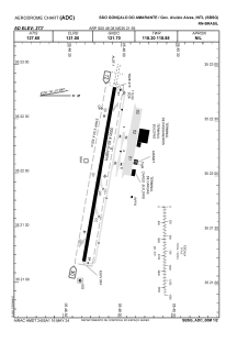


SBSG - São Gonçalo Do Amarante - Governador Aluizio Alves
Located in Natal, Brazil
ICAO - SBSG, IATA - NAT
Data provided by AirmateGeneral information
Coordinates: S5°46'8" W35°21'59"
Elevation is 273 feet MSL.
Magnetic variation is -21.42° East View others Airports in Rio Grande do Norte
Operational data
Special qualification required
Current time UTC:
Current local time:
Weather
METAR: SBSG 270100Z 14003KT 090V200 8000 -SHRA BKN008 BKN020 FEW035TCU BKN070 25/23 Q1011 RESHRA
TAF: TAF SBSG 262100Z 2700/2724 14015KT 7000 BKN015 FEW025TCU TN24/2708Z TX29/2717Z PROB40 2700/2703 4500 SHRA BECMG 2706/2708 18007KT BKN017 BECMG 2712/2714 14010KT 5000 TSRA BKN014 FEW030CB RMK PGU
Communications frequencies: [VIEW]
Runways:
| RWY identifier | QFU | Length (ft) | Width (ft) | Surface | LDA (ft) |
| 12 | 0° | 3120 | 300 | ASPH | |
| 30 | 0° | 3120 | 300 | ASPH |
Airport contact information
Address: Natal Brazil