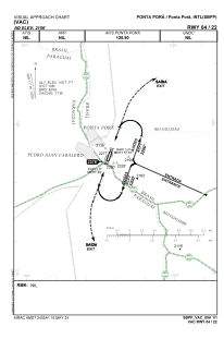
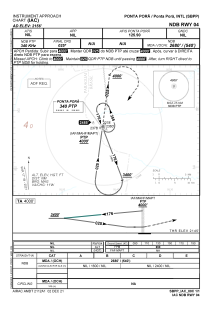
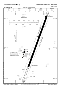


SBPP - Ponta Porã
Located in Ponta Porã, Brazil
ICAO - SBPP, IATA - PMG
Data provided by AirmateGeneral information
Coordinates: S22°32'59" W55°42'11"
Elevation is 2155 feet MSL.
Magnetic variation is -17.3° East View others Airports in Mato Grosso do Sul
Operational data
Special qualification required
Current time UTC:
Current local time:
Weather
TAF: TAF SBPP 030800Z 0312/0412 02010KT CAVOK TX31/0317Z TN27/0411Z BECMG 0313/0316 34015KT FEW020 BECMG 0317/0320 33010KT SCT020 FEW025TCU BECMG 0321/0323 33005KT FEW020 BECMG 0400/0402 00000KT CAVOK BECMG 0410/0412 02010KT RMK PGH
Communications frequencies: [VIEW]
Runways:
| RWY identifier | QFU | Length (ft) | Width (ft) | Surface | LDA (ft) |
| 04 | 20° | 6955 | 492 | ASPH | |
| 22 | 200° | 6955 | 492 | ASPH |
Airport contact information
Address: Ponta Porã Brazil