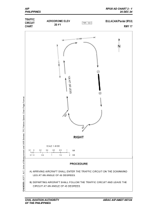


RPUX - Plaridel Community Airport
Located in Plaridel, Philippines
ICAO - RPUX, IATA -
Data provided by AirmateGeneral information
Coordinates: N14°53'30" E120°51'11"
Elevation is 19 feet MSL.
Magnetic variation is -3° East View others Airports in Bulacan
Operational data
Special qualification required
Current time UTC:
Current local time:
Weather at : RPLC - Diosdado Macapagal International Airport ( 45 km )
METAR: RPLC 280200Z 09006KT 9999 SCT020 34/24 Q1012 NOSIG RMK A2988
TAF: TAF RPLC 272300Z 2800/2906 18010KT 9999 FEW020 TX37/2806Z TN27/2821Z TEMPO 2800/2806 14012KT SCT020
Communications frequencies: [VIEW]
Runways:
| RWY identifier | QFU | Length (ft) | Width (ft) | Surface | LDA (ft) |
| 17 | 174° | 2953 | 98 | ASPH | 2953 |
| 35 | 354° | 2953 | 98 | ASPH | 2953 |
Airport contact information
Address: Plaridel Philippines
