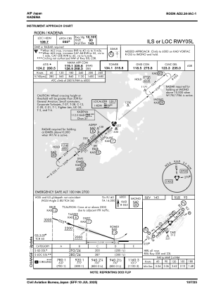
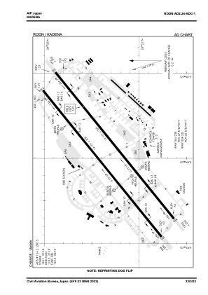


RODN - Kadena
Located in Kadena, Japan
ICAO - RODN, IATA - DNA
Data provided by AirmateGeneral information
Coordinates: N26°21'20" E127°46'3"
Elevation is 143 feet MSL.
View others Airports in Okinawa Prefecture
Operational data
Special qualification required
Current time UTC:
Current local time:
Weather
METAR: RODN 272355Z 16007KT 10SM SCT060 27/23 A2986 RMK AO2A SLP117 T02700234 10270 20233 52011 PWINO FZRANO $
TAF: TAF RODN 280000Z 2800/2906 14010KT 9999 FEW015 BKN050 BKN180 QNH2982INS TEMPO 2805/2810 8000 -SHRA BR BKN015 BECMG 2809/2810 18012KT 9999 BKN018 BKN100 QNH2980INS BECMG 2814/2815 20012G18KT 9000 -SHRA BKN014 BKN060 QNH2975INS BECMG 2816/2817 20012G20KT 8000 -SHRA BKN010 QNH2979INS TEMPO 2817/2820 4800 -SHRA BKN009 TX28/2805Z TN22/2821Z
Communications frequencies: [VIEW]
Runways:
| RWY identifier | QFU | Length (ft) | Width (ft) | Surface | LDA (ft) |
| 05R | 51° | 12101 | 200 | CON | |
| 23L | 231° | 12101 | 200 | CON | |
| 05L | 51° | 12101 | 300 | ASP | |
| 23R | 231° | 12101 | 300 | ASP |
Airport contact information
Address: Kadena Japan