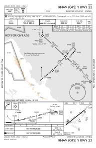
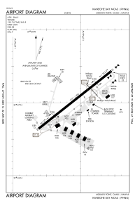


PHNG - Kaneohe Bay Mcas (Marion E Carl Fld)
Located in Kaneohe,
ICAO - NGF, IATA - NGF
Data provided by AirmateGeneral information
Coordinates: N21°27'2" W157°46'5"
Elevation is 23 feet MSL.
Magnetic variation is 10° East View others Airports in Hawaii
Operational data
Special qualification required
Current time UTC:
Current local time:
Weather
TAF: TAF PHNG 2609/2709 08012G20KT 9999 FEW025 SCT035 QNH3009INS TEMPO 2609/2615 09012KT BKN020 OVC035 FM261500 09014G25KT 9999 SCT020 SCT040 QNH3007INS TEMPO 2618/2700 8000 -SHRA BKN020 BKN035 BECMG 2703/2706 SCT020 BKN035 T23/2614Z T28/2623Z
Communications frequencies: [VIEW]
Runways:
| RWY identifier | QFU | Length (ft) | Width (ft) | Surface | LDA (ft) |
| 04 | 52° | 7771 | 200 | ASPH | |
| 22 | 232° | 7771 | 200 | ASPH |
Airport contact information
Address: Kaneohe