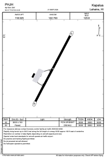


PHJH - Kapalua
Located in Lahaina,
ICAO - JHM, IATA - JHM
Data provided by AirmateGeneral information
Coordinates: N20°57'47" W156°40'23"
Elevation is 256 feet MSL.
Magnetic variation is 11° East View others Airports in Hawaii
Operational data
Special qualification required
Current time UTC:
Current local time:
Weather
TAF: PHJH 292322Z 3000/3024 03011KT P6SM BKN030 FM300200 06010KT P6SM FEW030 SCT050 FM300600 07006KT P6SM FEW035 SCT050 FM302000 31009KT P6SM FEW030 SCT050
Communications frequencies: [VIEW]
Runways:
| RWY identifier | QFU | Length (ft) | Width (ft) | Surface | LDA (ft) |
| 02 | 28° | 3000 | 100 | ASPH | 3000 |
| 20 | 208° | 3000 | 100 | ASPH | 3000 |
Airport contact information
Address: Lahaina