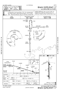


PAMC - Mc Grath
Located in Mc Grath,
ICAO - MCG, IATA - MCG
Data provided by AirmateGeneral information
Coordinates: N62°57'10" W155°36'25"
Elevation is 343 feet MSL.
Magnetic variation is 19° East View others Airports in Alaska
Operational data
Special qualification required
Current time UTC:
Current local time:
Weather
METAR: PAMC 061553Z AUTO 29003KT 10SM CLR 02/M01 A2947 RMK AO2 SLP985 T00171011 TSNO
TAF: PAMC 061127Z 0612/0712 30007KT P6SM SCT025 OVC040 FM070900 VRB04KT P6SM VCSH BKN050
Communications frequencies: [VIEW]
Runways:
| RWY identifier | QFU | Length (ft) | Width (ft) | Surface | LDA (ft) |
| 05 | 68° | 2000 | 60 | GRAVEL | |
| 23 | 248° | 2000 | 60 | GRAVEL | |
| 16 | 179° | 5936 | 100 | ASPH | 4843 |
| 34 | 359° | 5936 | 100 | ASPH | 4843 |
Airport contact information
Address: Mc Grath