


PAIL - Iliamna
Located in Iliamna,
ICAO - ILI, IATA - ILI
Data provided by AirmateGeneral information
Coordinates: N59°45'20" W154°55'4"
Elevation is 192 feet MSL.
Magnetic variation is 14° East View others Airports in Alaska
Operational data
Special qualification required
Current time UTC:
Current local time:
Weather
METAR: PAIL 062253Z 24009G17KT 10SM SCT013 SCT019 OVC047 04/00 A2954 RMK AO2 SLP007 T00390000
TAF: PAIL 062158Z 0622/0718 22010G20KT P6SM SCT015 BKN040 FM070200 20008KT P6SM BKN035 FM070800 12008KT P6SM -SHRA OVC025 FM071400 09006KT 4SM -RA OVC015
Communications frequencies: [VIEW]
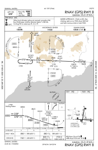
Runways:
| RWY identifier | QFU | Length (ft) | Width (ft) | Surface | LDA (ft) |
| 08 | 92° | 5086 | 100 | ASPH | |
| 26 | 272° | 5086 | 100 | ASPH | |
| 18 | 189° | 4800 | 100 | ASPH | |
| 36 | 9° | 4800 | 100 | ASPH | |
| E | 0° | 2998 | 400 | WATER | |
| W | 0° | 2998 | 400 | WATER | |
| N | 0° | 2892 | 400 | WATER | |
| S | 0° | 2892 | 400 | WATER |
Airport contact information
Address: Iliamna