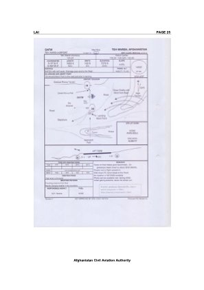


OATW - Teh Wareh Airport
Located in Tewara, Afghanistan
ICAO - , IATA -
Data provided by AirmateGeneral information
Coordinates: N33°32'24" E64°25'30"
Elevation is 7370 feet MSL.
Magnetic variation is 3° East View others Airports in Ghor Province
Operational data
Special qualification required
Current time UTC:
Current local time:
Weather at : - ( 0 km )
METAR: CYEN 081224Z AUTO 06019G28KT 9SM BKN008 BKN044 OVC060 10/09 A2966 RMK SLP059
Communications frequencies: [VIEW]
Runways:
| RWY identifier | QFU | Length (ft) | Width (ft) | Surface | LDA (ft) |
| 18 | 0° | 1950 | 100 | DIRT | |
| 36 | 0° | 1950 | 100 | DIRT |
Airport contact information
Address: Tewara Afghanistan