


O21 - Hoopa
Located in Hoopa, United States
ICAO - O21, IATA -
Data provided by AirmateGeneral information
Coordinates: N41°2'29" W123°40'4"
Elevation is 356 feet MSL.
Magnetic variation is 17° East View others Airports in California
Operational data
Special qualification required
Current time UTC:
Current local time:
Weather at : KACV - California Redwood Coast-Humboldt County ( 38 km )
METAR: KACV 300553Z AUTO 05003KT 10SM CLR 06/04 A3023 RMK AO2 SLP243 T00610039 10128 20061 51005
TAF: KACV 300531Z 3006/0106 01004KT P6SM FEW025 FM301000 04003KT P6SM SCT025 BKN035 BKN250 FM301800 33014KT P6SM FEW025 SCT035 FM302100 33018G27KT P6SM SCT250 FM010400 35006KT P6SM SKC
Communications frequencies: [VIEW]
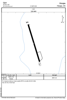
Runways:
| RWY identifier | QFU | Length (ft) | Width (ft) | Surface | LDA (ft) |
| 14 | 0° | 2325 | 50 | ASPH | |
| 32 | 0° | 2325 | 50 | ASPH |
Airport contact information
Address: Hoopa United States