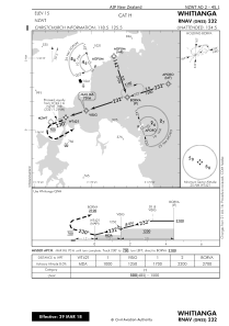


NZWT - Whitianga
Located in Whitianga, New Zealand
ICAO - NZWT, IATA - WTZ
Data provided by AirmateGeneral information
Coordinates: S36°49'54" E175°40'43"
Elevation is 15 feet MSL.
Magnetic variation is +20° East View others Airports in Waikato Region
Operational data
Special qualification required
Current time UTC:
Current local time:
Weather at : - ( 0 km )
METAR: KDVP 270433Z AUTO 03003KT 7SM -RA OVC004 10/09 A2940 RMK AO2 P0003 T00980091
Communications frequencies: [VIEW]
Runways:
| RWY identifier | QFU | Length (ft) | Width (ft) | Surface | LDA (ft) |
| 16 | 178° | 2421 | 98 | GRASS | 2329 |
| 34 | 358° | 2421 | 98 | GRASS | 2192 |
| 04 | 55° | 4744 | 98 | GRASS | 4416 |
| 22 | 235° | 4744 | 98 | GRASS | 4744 |
Airport contact information
Address: Whitianga New Zealand
