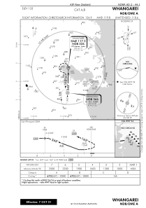


NZWR - Whangarei
Located in Whangarei, New Zealand
ICAO - NZWR, IATA - WRE
Data provided by AirmateGeneral information
Coordinates: S35°46'6" E174°21'54"
Elevation is 133 feet MSL.
Magnetic variation is +19° East View others Airports in Northland Region
Operational data
Special qualification required
Current time UTC:
Current local time:
Weather at : - ( 0 km )
METAR: KNLC 281156Z AUTO 31005KT 10SM CLR 10/07 A3006 RMK AO2 SLP179 T01000067 10150 20089 55004 $
Communications frequencies: [VIEW]
Runways:
| RWY identifier | QFU | Length (ft) | Width (ft) | Surface | LDA (ft) |
| 06 | 0° | 3599 | 98 | BITUM | 3501 |
| 24 | 0° | 3599 | 98 | BITUM | 3599 |
| 14 | 156° | 1460 | 197 | GRASS | 1460 |
| 32 | 336° | 1460 | 197 | GRASS | 1460 |
Airport contact information
Address: Whangarei New Zealand
