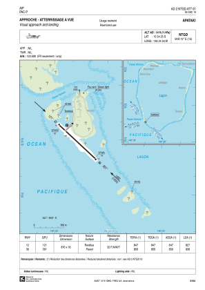


NTGD - Apataki
Located in , French Polynesia
ICAO - NTGD, IATA - APK
Data provided by AirmateGeneral information
Coordinates: S15°34'25" W146°24'54"
Elevation is 14 feet MSL.
Magnetic variation is 12.36° East View others Airports in (unassigned)
Operational data
Special qualification required
Current time UTC:
Current local time:
Weather at : - ( 0 km )
METAR: TXKF 260855Z 34007KT 9999 BKN049 18/09 Q1019
Communications frequencies: [VIEW]
Runways:
| RWY identifier | QFU | Length (ft) | Width (ft) | Surface | LDA (ft) |
| 12 | 133° | 2854 | 59 | ASPH | 2713 |
| 30 | 313° | 2854 | 59 | ASPH | 2723 |
Airport contact information
Address: French Polynesia