


MU97 - Lexington Muni
Located in Lexington, United States
ICAO - MU97, IATA -
Data provided by AirmateGeneral information
Coordinates: N39°12'36" W93°55'40"
Elevation is 691 feet MSL.
Magnetic variation is 04° East View others Airports in Missouri
Operational data
Special qualification required
Current time UTC:
Current local time:
Weather at : KGPH - Midwest Ntl Air Center ( 36 km )
METAR: KGPH 260535Z AUTO 13010G16KT 10SM BKN009 BKN015 BKN120 11/11 A2985 RMK AO2
Communications frequencies: [VIEW]
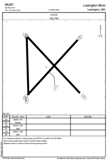
Runways:
| RWY identifier | QFU | Length (ft) | Width (ft) | Surface | LDA (ft) |
| 04 | 42° | 2925 | 40 | ASPH | |
| 22 | 222° | 2925 | 40 | ASPH | |
| 13 | 136° | 3100 | 125 | GRASS | |
| 31 | 316° | 3100 | 125 | GRASS | |
| 18 | 180° | 2250 | 125 | GRASS | |
| 36 | 0° | 2250 | 125 | GRASS |
Airport contact information
Address: Lexington United States