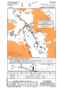


MMTO - Toluca Aeropuerto Internacional Lic. Adolfo Lopez Mateos
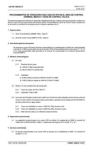
Located in Toluca, Mexico
ICAO - MMTO, IATA - TLC
Data provided by AirmateGeneral information
Coordinates: N19°20'14" W99°33'58"
Elevation is 8466 feet MSL.
View others Airports in Mexico
Operational data
Special qualification required
Current time UTC:
Current local time:
Weather
METAR: MMTO 192041Z 03011KT 7SM BKN020TCU 27/03 A3034 RMK SLP024 57022 910 8/200 HZY
TAF: TAF MMTO 191731Z 1918/2018 05010KT 5SM HZ SCT020 TX27/1921Z TN12/2012Z BECMG 1921/1922 SCT020CB TEMPO 1923/2001 5SM TSRA BKN020CB FM200300 34005KT P6SM SCT020 SCT080 FM201200 00000KT 4SM HZ SCT020 TEMPO 2012/2014 BKN015
Communications frequencies: [VIEW]
Runways:
| RWY identifier | QFU | Length (ft) | Width (ft) | Surface | LDA (ft) |
| 15 | 157° | 13780 | 148 | ASP | |
| 33 | 337° | 13780 | 148 | ASP |
Airport contact information
Address: Toluca Mexico