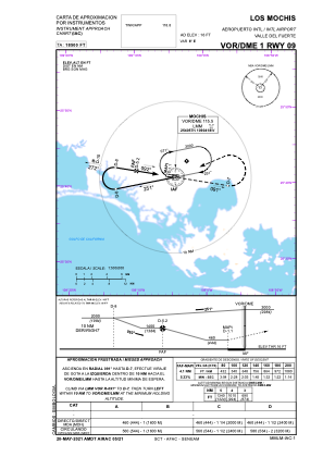
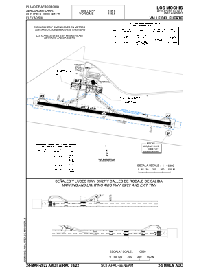


MMLM - Los Mochis Aeropuerto Internacional Valle Del Fuerte
Located in Los Mochis, Mexico
ICAO - MMLM, IATA - LMM
Data provided by AirmateGeneral information
Coordinates: N25°41'8" W109°4'52"
Elevation is 16 feet MSL.
View others Airports in Sinaloa
Operational data
Special qualification required
Current time UTC:
Current local time:
Weather
METAR: MMLM 040145Z 23005KT 10SM SCT220 24/16 A2977 RMK 8/001
TAF: TAF MMLM 031650Z 0318/0418 26015KT P6SM SKC FM040300 26005KT P6SM SKC FM040900 00000KT 5SM HZ SCT010 TEMPO 0410/0414 1SM BR FM041500 00000KT P6SM SKC
Communications frequencies: [VIEW]
Runways:
| RWY identifier | QFU | Length (ft) | Width (ft) | Surface | LDA (ft) |
| 09 | 100° | 6585 | 148 | ASP | |
| 27 | 280° | 6585 | 148 | ASP |
Airport contact information
Address: Los Mochis Mexico