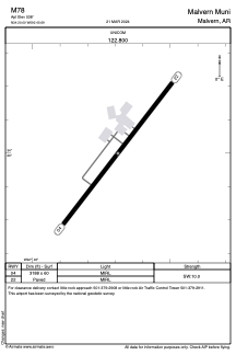


M78 - Malvern Muni
Located in Malvern, United States
ICAO - M78, IATA -
Data provided by AirmateGeneral information
Coordinates: N34°19'60" W92°45'41"
Elevation is 538 feet MSL.
Magnetic variation is 04° East View others Airports in Arkansas
Operational data
Special qualification required
Current time UTC:
Current local time:
Weather at : KHOT - Meml Fld ( 35 km )
METAR: KHOT 261853Z AUTO 17007KT 140V200 10SM FEW024 BKN050 OVC060 23/18 A2988 RMK AO2 PK WND 18029/1811 LTG DSNT W SLP113 T02330178
TAF: KHOT 261929Z 2619/2718 17010G16KT P6SM SCT025 BKN050 FM262200 18012G20KT 5SM SHRA BR VCTS SCT020CB OVC050 TEMPO 2622/2702 VRB15G30KT 1SM TSRA BR OVC020CB FM270600 17009KT P6SM BKN025 FM271200 15011G17KT P6SM BKN015
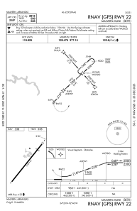
Communications frequencies: [VIEW]
Runways:
| RWY identifier | QFU | Length (ft) | Width (ft) | Surface | LDA (ft) |
| 04 | 38° | 3188 | 60 | ASPH | |
| 22 | 218° | 3188 | 60 | ASPH |
Airport contact information
Address: Malvern United States