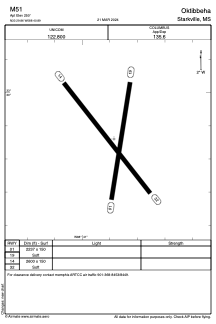


M51 - Oktibbeha
Located in Starkville, United States
ICAO - M51, IATA -
Data provided by AirmateGeneral information
Coordinates: N33°29'52" W88°40'53"
Elevation is 250 feet MSL.
Magnetic variation is 02° East View others Airports in Mississippi
Operational data
Special qualification required
Current time UTC:
Current local time:
Communications frequencies: [VIEW]
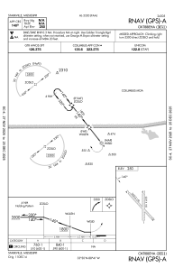
Runways:
| RWY identifier | QFU | Length (ft) | Width (ft) | Surface | LDA (ft) |
| 01 | 8° | 2237 | 150 | GRASS | |
| 19 | 188° | 2237 | 150 | GRASS | |
| 14 | 142° | 2600 | 150 | GRASS | |
| 32 | 322° | 2600 | 150 | GRASS |
Airport contact information
Address: Starkville United States