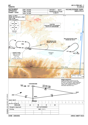
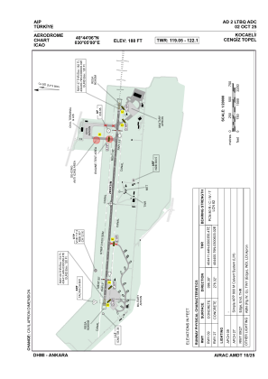


LTBQ - Kocaeli Cengiz Topel
Located in Kocaeli/Topel, Turkey
ICAO - LTBQ, IATA - KCO
Data provided by AirmateGeneral information
Coordinates: N40°44'6" E30°4'60"
Elevation is 188 feet MSL.
Magnetic variation is 5.4° East View others Airports in Kocaeli
Operational data
Special qualification required
Current time UTC:
Current local time:
Weather
METAR: LTBQ 300050Z 00000KT 7000 BKN010 BKN020 13/13 Q1020 TEMPO 4000 BR
TAF: TAF LTBQ 292240Z 3000/3009 VRB02KT 6000 SCT010 BKN020 TEMPO 3000/3003 4000 -RA BR BKN010 BKN020 PROB40 TEMPO 3003/3006 2500 -RA BR BKN010 BKN020
Communications frequencies: [VIEW]
Runways:
| RWY identifier | QFU | Length (ft) | Width (ft) | Surface | LDA (ft) |
| 09 | 96° | 9810 | 98 | CONC | 9810 |
| 27 | 276° | 9810 | 98 | CONC | 9810 |
Airport contact information
Address: Kocaeli/Topel Turkey